Fire’s Footprint on Santa Rosa Island
Earth Observatory Science Earth Observatory Fire’s Footprint on Santa… Earth Earth Observatory Image of the Day EO Explorer Topics All Topics Atmosphere Land Heat & Radiation Life on Earth Human Dimensions Natural Events Oceans Remote Sensing Technology Snow & Ice Water More Content Collections Global Maps World of Change Articles Notes from the Field Blog Earth Matters Blog Blue Marble: Next Generation EO Kids Mission: Biomes About About Us Subscribe 🛜 RSS Contact Us Search
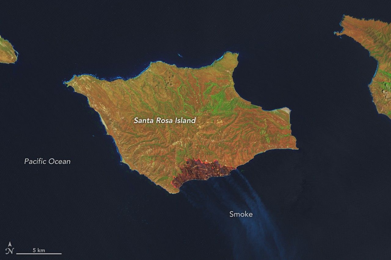
Earth Observatory Science Earth Observatory Fire’s Footprint on Santa… Earth Earth Observatory Image of the Day EO Explorer Topics All Topics Atmosphere Land Heat & Radiation Life on Earth Human Dimensions Natural Events Oceans Remote Sensing Technology Snow & Ice Water More Content Collections Global Maps World of Change Articles Notes from the Field Blog Earth Matters Blog Blue Marble: Next Generation EO Kids Mission: Biomes About About Us Subscribe 🛜 RSS Contact Us Search May 16, 2026 May 24, 2026 A false-color image of Santa Rosa Island from May 16, 2026, shows a dark-brown burned area toward the bottom-right. A thin, bright orange line runs along the burned area, indicating the active fire front. NASA Earth Observatory / Lauren Dauphin A false-color image of Santa Rosa Island from May 24, 2026, shows a reddish-brown burned area spanning the eastern third of the island. NASA Earth Observatory / Lauren Dauphin May 16, 2026 May 24, 2026 A false-color image of Santa Rosa Island from May 16, 2026, shows a dark-brown burned area toward the bottom-right. A thin, bright orange line runs along the burned area, indicating the active fire front. NASA Earth Observatory / Lauren Dauphin A false-color image of Santa Rosa Island from May 24, 2026, shows a reddish-brown burned area spanning the eastern third of the island. NASA Earth Observatory / Lauren Dauphin May 16, 2026 May 24, 2026 Curtain Toggle 2-Up Image Details The burned area from a wildland fire on Santa Rosa Island in California’s Channel Islands National Park grows between May 16 (left) and May 24, 2026 (right), in these false-color images captured by the OLI (Operational Land Imager) on Landsat 9 and Landsat 8 , respectively. On May 15, 2026, a fire was spotted from aircraft on the southeastern side of Santa Rosa Island, part of California’s Channel Islands National Park. The blaze spread over the next several days, ultimately burning 18,379 acres (7,438 hectares)—about one-third of the island. These images show the expansion of the fire’s burned area between May 16 (left), the day after it was discovered, and May 24 (right), after the fire’s growth had stabilized . The Landsat satellite images are false-color to help distinguish burned areas (brown) from healthy vegetation (green). Officials reported the fire was 97 percent contained by the evening of May 26. NASA tools utilizing satellite observations, namely FIRMS (Fire Information for Resource Management System) and the Fire Event Explorer , show how the fire spread to the north and east over several days. As it advanced, it consumed areas of grassland, coastal sage scrub, and island chaparral . Santa Rosa Island, like the other Channel Islands, is known for its diversity of plant and animal species, some of them rare. Observers were concerned that the fire threatened the island’s Torrey pines , a rare type of tree that in the United States grows naturally only on the northeastern coast of Santa Rosa Island and near San Diego. Initial post-fire surveys by firefighters and unmanned aircraft indicated the Torrey pine stand remained largely intact. The fire mostly burned at lower intensity through the pine areas and spared the canopy. However, some pockets of forest sustained damage where intensity was higher. Along the northwest edge of the fire, suppression crews worked to protect another vulnerable area—the cloud forests —by cooling fuels ahead of the fire’s front. Local reports suggest the Santa Rosa Island fire is the largest on record on any of California’s Channel Islands. Some of the islands’ chaparral and tree species are adapted to fire but less dependent on it than their mainland counterparts, according to the National Park Service, because naturally occurring fire is less frequent on the Channel Islands. NASA Earth Observatory images by Lauren Dauphin, using Landsat data from the U.S. Geological Survey . Story by Lindsey Doermann. Downloads May 16, 2026 JPEG (2.50 MB) May 24, 2026 JPEG (2.34 MB) References & Resources Capital Public Radio (2020) California Wildfire History Map . Accessed May 29, 2026. InciWeb (2026, May 28) Santa Rosa Island Fire . Accessed May 29, 2026. NASA Earth Observatory (2026, May 20) Fire Chars Santa Rosa Island . Accessed May 29, 2026. National Park Service, Channel Islands . Accessed May 29, 2026. Santa Barbara Independent (2026, May 21) What We’re Losing in the Santa Rosa Island Fire . Accessed May 29, 2026. You may also be interested in: Stay up-to-date with the latest content from NASA as we explore the universe and discover more about our home planet. Fire Chars Santa Rosa Island 2 min read The blaze spread across the southern side of the second-largest island in California’s Channel Islands National Park. Article Fires Tear Through Nebraska Grasslands 3 min read Dry, warm, and windy conditions across the U.S. Great Plains led to extreme fire activity in March 2
📌 Kaynak
Bu özet NASA Breaking News kaynağından otomatik derlenmiştir. Tamamı için orijinal habere gidin.
Orijinal haberi oku →