Curiosity Blog, Sols 4908-4912: Goodbye Campo Marte, It’s Been Fun!
Curiosity Navigation Curiosity Home Mission Overview Where is Curiosity? Mission Updates Science Overview Instruments Highlights Exploration Goals News and Features Multimedia Curiosity Raw Images Images Videos Audio Mosaics More Resources Mars Missions Mars Perseverance Rover Mars Curiosity Rover MAVEN Mars Reconnaissance Orbiter Mars Odyssey More Mars Missions Mars Home 5 min read Curiosity Blog, Sols 4908-4912: Goodbye Campo Marte, It’s Been Fun! NASA’s Mars rover Curiosit
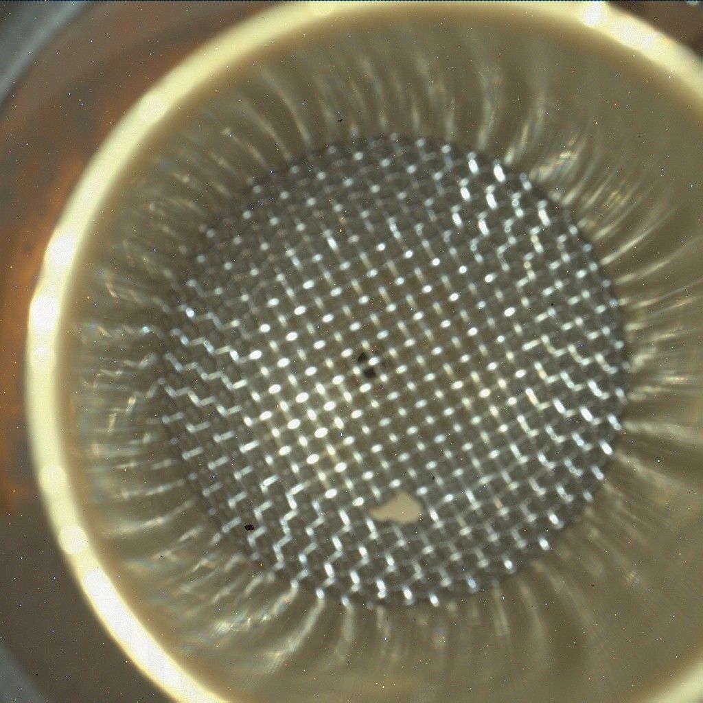
Curiosity Navigation Curiosity Home Mission Overview Where is Curiosity? Mission Updates Science Overview Instruments Highlights Exploration Goals News and Features Multimedia Curiosity Raw Images Images Videos Audio Mosaics More Resources Mars Missions Mars Perseverance Rover Mars Curiosity Rover MAVEN Mars Reconnaissance Orbiter Mars Odyssey More Mars Missions Mars Home 5 min read Curiosity Blog, Sols 4908-4912: Goodbye Campo Marte, It’s Been Fun! NASA’s Mars rover Curiosity acquired this image of the inlet on its Chemistry & Mineralogy X-Ray Diffraction instrument (CheMin), which is about the size of a laptop computer and sits inside rover’s body, where it analyzes the chemical composition of rocks and soil. Curiosity captured the image using its Mars Hand Lens Imager (MAHLI), a close-up camera located on the turret at the end of the rover’s robotic arm, on May 28, 2026 — Sol 4908, or Martian day 4,908 of the Mars Science Laboratory Mission — at 11:14:14 UTC. NASA/JPL-Caltech/MSSS By Susanne P. Schwenzer, Professor of Planetary Mineralogy at The Open University, UK Earth planning date: Friday, May 29, 2026 Drilling always keeps the rover in place for a little while, and our 47th successful drill, “Campo Marte,” was no exception. The team used the time wisely and on top of the drilling, we also have many observations. Thinking for a long time about a workspace always gets me attached to the area — some more than others; at the shorter stops, especially — when I am on shift several times during this time. I was Science Operations Working Group chair three times while we were here, so it’s a real “Goodbye” for me today as we are driving onward to reach the next area up the hill on Mount Sharp. The Campo Marte drill was successful, as my colleague Abigail Fraeman reported last week . This week was spent investigating the aftermath of the drilling, which means running the CheMin instrument to get mineralogical data and the SAM instrument to inspect the volatile releases. ChemCam, APXS, MAHLI and Mastcam were also busy documenting the drill hole and the drill fines, as well as how much sample there was available overall. Of course, Curiosity also had a very good look at the other interesting targets in the area! Besides all the work on the drill hole, ChemCam carried out an expert’s targeting exercise by setting two targets up to aim at two different layers on adjacent spots on the finely laminated sediments. That involves aiming at millimeter-sized targets, named “Corcovado” and “Junakas,” respectively, about 3 meters away (about 10 feet)! We are curious if the layers are chemically different, which would tell us about different formation conditions, or if they are similar and the conditions when those layers formed were more similar. ChemCam is also looking at the target “Palcaya” to get more data on the chemistry of the layered bedrock, and will investigate the target “Alcamachi,” which is a float rock that looks intriguingly dark. Maybe that tells us it’s got a different chemistry? We will find out when we get the data! In addition to the chemistry measurements, ChemCam will also carry out a spectral investigation on the target “Magallanas,” which was a little too far away to also point the laser at it, but is intriguingly dark. This last week, ChemCam also planned three long-distance RMIs to document the sedimentary structures — younger and older ones — in the surrounding area. One of them drew the suspicion that it might break a record: it might be the longest strip of RMI images we have taken in one mosaic! The jury is out, it’s 24 frames and this way links up with an earlier, shorter set of images. The reason the mosaic is so long is because it images a small ridge with sedimentary textures that could tell us about the depositional conditions when the rock layers formed. But how cool is that — at 13+ years to still break our own records? Since our arrival, Mastcam has been very busy getting the entire region around us imaged. In addition, some higher-resolution mosaics have been taken, most notably one of the locations where the remaining sample was dropped, and then of the workspace to see again how much sample might — or might not — have been left in the drill stem and fallen out when Curiosity did the motions that are designed to shake any remaining sample out of the drill, to leave it prepared for the next time. Another imaging task, but for MAHLI, is to always image the sample inlets, also, to see if they are clean and prepared for the next sample. I included the MAHLI image of the CheMin inlet — don’t worry about the little rock, it’s with us for a while, and the CheMin team now calls it “our pet rock.” APXS joined the drill-hole investigations and has been focused on it even more than usual. The team decided that this is a very good opportunity to increase counting statistics beyond the usual and
📌 Kaynak
Bu özet NASA Breaking News kaynağından otomatik derlenmiştir. Tamamı için orijinal habere gidin.
Orijinal haberi oku →