Heavy silt deposits give illusion Attabad is ‘drying up’
RECENT photos and videos of the Attabad Lake in Gilgit-Baltistan seem to show that the size of the water body has shrunken considerably. But the phenomenon at play here is not a drying-up of the lake, rather heavy silt and sedimentation encroaching on the lake bed, according to an iVerify fact check published on Friday. Known as GB’s “crown jewel” and a major tourist attraction, the lake was formed after the Attabad village in the Gojal Valley witnessed a major landslide on J
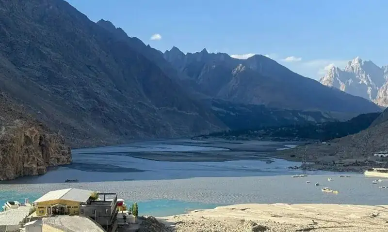
RECENT photos and videos of the Attabad Lake in Gilgit-Baltistan seem to show that the size of the water body has shrunken considerably. But the phenomenon at play here is not a drying-up of the lake, rather heavy silt and sedimentation encroaching on the lake bed, according to an iVerify fact check published on Friday. Known as GB’s “crown jewel” and a major tourist attraction, the lake was formed after the Attabad village in the Gojal Valley witnessed a major landslide on January 4, 2010. Recent visuals of the lake have had netizens talking, showing large parts of its once-turquoise waters replaced by dry, exposed land. Many raised concerns over a “visible decline in water levels”, linking it to environmental degradation, while other argued that the apparent drying was a usual phenomenon. Jamil Nagri, Dawn’s correspondent in Gilgit, confirmed the authenticity of the visuals circulating on social media. But the size of the lake, which is not a natural water body, rather a landslide-dammed reservoir, is susceptible to influence from factors such as inflows from multiple sources and outflow management through spillways constructed to reduce pressure on the natural dam. According to a 2024 research paper authored by personnel from the China Geological Survey, a gradual reduction in the lake’s surface area had been observed between 2010 and 2020. According to the authors of the story, titled Changes in the Hydrological Characteristics of the Attabad Landslide-Dammed Lake on the Karakoram Highway, sediment accumulated in the lake’s upstream northern estuary as the water body evolved over time, increasing the extent of exposed sediment deposits and altering the surrounding landscape. “Because of its proximity to the source of the Hunza River, the lake experiences rapid silting. Over time, this natural sedimentation gradually shrinks the active water area and alters the surrounding landscape,” the paper noted. The study observed that changes in the lake became less pronounced after 2016, suggesting that the water body was moving towards a more stable state. “The lake has not dried up; instead, it is shrinking due to high levels of silt in the lake, which is a natural phenomenon,” a GB-based climate expert said. He explained that there was siltation in the summer from tributaries, which made it look like the lake was drying up. This fact check was originally published by iVerify Pakistan — a project of CEJ and UNDP Published in Dawn, June 6th, 2026
📌 Kaynak
Bu özet Dawn (PK) kaynağından otomatik derlenmiştir. Tamamı için orijinal habere gidin.
Orijinal haberi oku →